ROTHERHAM HABITAT BANK
South Anston, Rotherham
Local Planning Authority
Rotherham Metropolitan Borough Council
National Character Area
Southern Magnesian Limestone
Local Nature Recovery Strategy Area
South Yorkshire
Biodiversity Gain Site Reference
tbc
Status
Pending legals - units available for reservation
At Rotherham Habitat Bank, we are creating a diverse landscape of species-rich meadows, native woodland, traditional orchard, mixed scrub, hedgerows and enhanced ditches across 72.5 hectares at South Anston, between Sheffield and Worksop.
The habitats are designed to work together as a connected mosaic, strengthening connectivity between existing woodland, grassland and hedgerows and creating better links for wildlife across the site and into the wider landscape, supporting long-term nature recovery.
Rotherham Habitat Bank provides a broad choice of habitat, hedgerow and watercourse Biodiversity Units across medium, high and very high distinctiveness categories, suitable for a wide range of developments, including schemes with more complex requirements.
Units are available to reserve ahead of the Habitat Bank being legally secured and registered on Natural England’s Biodiversity Gain Sites Register, anticipated in late 2026, with allocations available thereafter.

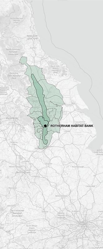
Rotherham Habitat Bank Location
Local Coverage
Rotherham Habitat Bank is located in:
-
Southern Magnesian Limestone National Character Area
-
Rotherham Metropolitan Borough Council Local Planning Authority
It is therefore ideally located to provide Biodiversity Units for local developments in Rotherham and within the Southern Magnesian Limestone NCA, including parts of:
-
Leeds City Council
-
North Yorkshire Council
-
Wakefield Council
-
City of Doncaster Council
-
Bassetlaw District Council
-
Bolsover District Council
Adjacent Coverage
Rotherham Habitat Bank can also provide cost-effective Biodiversity Units for developments in adjacent NCAs and LPAs:
-
Mansfield District Council
-
Ashfield District Council
-
Gedling Borough Council
-
Nottingham City Council
-
Broxtowe Borough Council
National Character Areas
-
Pennine Dales Fringe
-
Vale of Mowbray
-
Vale of York
-
Humberhead Levels
-
Sherwood
-
Nottinghamshire, Derbyshire & Yorkshire Coalfield
Local Planning Authorities
-
Barnsley Metropolitan Borough Council
-
North East Derbyshire District Council
-
Sheffield City Council
Biodiversity Units can also be supplied for developments nationally. Watercourse units are assessed separately using catchment-based spatial risk rules.
Biodiversity Units at Rotherham Habitat Bank
Very High Distinctiveness
-
Lowland meadow
High Distinctiveness
-
Traditional orchard
-
Lowland mixed deciduous woodland
-
Species-rich native hedgerow with trees
Medium Distinctiveness
-
Other neutral grassland
-
Other woodland; broadleaved
-
Mixed scrub
-
Ditches - watercourse units
HABITAT UNITS
Total Habitat Units
381.44
Habitat Types
-
Lowland meadow
-
Traditional orchard
-
Lowland mixed deciduous woodland
-
Other neutral grassland
-
Other woodland; broadleaved
-
Mixed scrub
HEDGEROW UNITS
Total Hedgerow Units
34.59
Hedgerow Types
-
Species-rich native hedgerow with trees
WATERCOURSE UNITS
Total Watercourse Units
1.46
Watercourse Habitat
-
Ditches